
INTRODUCTION TO MONKS COWL AND CHAMPAGNE VALLEY (CATHKIN PARK) HIKING TRAILS
Monks Cowl and Champagne Valley (Cathkin Park) hiking trails are amongst the most popular in the Drakensberg. Most of these trails commence at Ezemvelo KZN Wildlife’s Monks Cowl Camp. These trails include Sterkspuit Falls, Nandi’s Falls, Keartlands Pass, Blindman’s Corner, the Spinx and Crystal Falls, Hlatikhulu Forest and Makhulumane Rock and Forest—also, Sterkhorn, Gatberg, Gray’s Pass, the Monks Cowl to Injisuthi hike, Zulu Cave , Wonder Valley Cave and the Sunset Trail.
The Cleos Falls Hike starts at the Oaks Supermarket or Drakensberg Sun. The Fern Forest and Blue Grotto hike start at Drakensberg Sun.
Monks Cowl Camp has a magnificent grassed camping site, a convenience store, and a daywalker parking area. A special area is available for overnight hikers to park their cars.
Consider using a qualified and registered hiking guide or mountain guide for these trails. Drakensberg Walking Excursions will be happy to assist you. Hiking guides help to enhance a hiking experience, ensure that you do not get lost and ensure your safety in the event of an emergency,
STERKSPRUIT FALLS
This easy walk starts at the Monks Cowl Camp of KZN Wildlife. It is marked and is roughly 4 km in length and 1.5 hours in duration. The highlight of this walk is the view of the spectacular Sterkspruit Falls.


KEARTLAND’S PASS, BLINDMAN’S CORNER, THE SPHINX AND CRYSTAL FALLS.

Moderate walk. Because this is a circular route with some uphills, it is described as mild to challenging. It is well-marked. It starts at Monks Cowl Camp. Follow the signs to Keartland’s Pass and Nandi’s Falls. You will reach an intersection where the path splits into Nandi’s Falls and Keartland’s Pass.
Moreover, be careful to follow the path to Keartland’s Pass. The Keartland’s Pass route intersects with the Contour Path. Turn right towards Blind Man’s Corner. Turn back at Blind Man’s corner and follow the Sphinx route to Monks Cowl. Also, en route, you will encounter the magnificent Crystal Falls. You can also do the hike in the reverse of the abovementioned. Some 11.5km and approximately 6 hours in duration.

NANDI’S FALLS
An easy walk from the Monks Cowl Camp. Well marked. 8km. 2.5 hrs.

HLATHIKULU FOREST HIKE
This is a moderate hike of some nine kilometres in total, with an elevation gain of some 400m. The duration is approximately three hours. Start at Monks Cowl Camp and follow the cairns marked Mkhulumane Rock and Hlathikulu Forest. Cross the Mpofane River at Cairn Six and ascend to a cairn that shows the route onto Mkulumani Rock, and then leave for Hlathikhulu Forest. Continue along the path. You will encounter a magnificent forest and a route back down to the river and Monks Cowl Camp. Alternatively, follow the route to Nandi Falls, cross the Sterkspruit River at the point marked one on the following map and up to the Hlathikulu Forest marked two and then onto Monks Cowl Camp. Please note that various sources spell this forest’s name differently – Hlathikhulu, Hlathikulu, Hlatikhulu and Hlatikulu.


MAKHULUMANI ROCK HIKE
The Makhulumani Rock hike is a moderate day hike of some four hours and nine kilometres. This hike begins at Monks Cowl Camp or Bergview Estate. From Monks Cowl, follow the path and signs to Makhulumani Rock. Cross the Mpofane River (at cairn number 6) until you meet a junction at the coordinates -29.04022 and 29.39365. Turn left up a path that meanders up a small valley and stream.

You will encounter the large ‘monolith’ Makhulumani, breathtaking forests, waterfalls, and a steep section of wooden ladders that takes you to the top of this valley.


JACOB’S LADDER AND STABLE CAVE HIKE
Jacob’s Ladder and the Stable Cave Hike is one of the longer hikes from the Monks Cowl Camp. This trail can be completed in a day, but it is recommended that hikers stay overnight at Stable Cave.

The hike duration is ten hours, and the total length is 20 kilometres. Take the route to Hlatikhulu Forest and cross the Mpofane River at the cairn marked six on the KZN Wildlife map for the area. Follow the way to the Hlatikhulu Forest and Makhulamane Rock. At the fork of the Hlatikhule Forest, follow the route to Makhulamane Rock. At the turn to Makhulamane Rock, carry straight ahead to Van Damm’s Cascade and Jacob’s Ladder. Be careful to fill up with water at Van Damm Cascade as there is no water on Jacob’s Ladder and very often none in Stable Cave.
Ascend Jacob’s Ladder. At the top, turn right to an entrance in the fence. You will pass a spectacular sandstone overhang. Enjoy the magnificent views of the Valley below and Cape Vulture soaring overhead. The path turns to the right at a ‘V’ in this formation.
The path follows a series of zig-zags for a while and then a slight uphill. At the top of this hill, you will note that the trail forks to the left. Follow this fork along a ridge. Finally, you will note the opening to the Stable Cave shelter.

Stable Cave is a long sandstone overhang that can easily sleep up to twelve people. Enjoy the views of Cathedral Peak on the horizon.

THE BLUE GROTTO AND FERN FOREST
These hikes can be done separately. However, it is recommended that you combine the two into one walk. The Route is marked from the Drakensberg Sun Hotel. The hike can be described as easy to moderate. It is a hike of some 10km in length and 4 hours in duration. You will encounter two spectacular waterfalls and a crystal-clear pool in the Blue Grotto. The Fern Forest is a “fairy garden” of cascading streams and dense clumps of ferns.


CLEO’S POOL
This hike starts at the Drakensberg Sun Activity Centre or Bergview and is well-marked. 7.5km. It takes just over 3 hours. Easy. The falls are in the Monks Cowl Reserve. This hike can also be approached from this area’s Dragon Peaks/ Oaks Supermarket side. The following map illustrates one of the routes that can be followed, starting at the Dragon Peaks Resort.


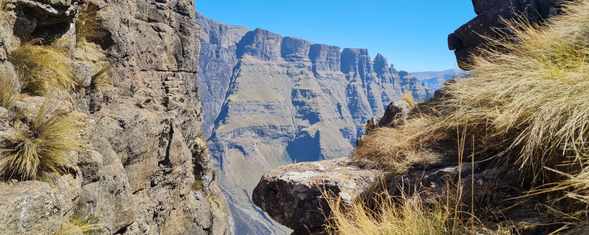
GRAY’S PASS:
The hike up Gray’s Pass is one of the more accessible routes to experience the wonder of the Drakensberg escarpment and observe the rugged beauty of some of its most prominent peaks. Moreover, it is one of the best routes to reach the plateau of ‘Champagne Castle.’ However, it is a hike that should not be underestimated. It is a moderate to strenuous hike of some 40 km, particularly if a hiker intends to explore the top section and walk across to the top of the ‘Champagne Castle plateau.’
The hike starts at Monks Cowl Camp. Remember to complete the mountain register and to indicate that you will be away for at least two nights. Take the route to the Sphinx and then the contour path to Blindman’s Corner. Keep to the left of the cairn, which marks Blindsman’s Corner and keep left onto the trail to Hlatikulu Nek. At the base of Hlatikulu Nek, turn left to enter the valley of the Mhlawazini River River. This area is also referred to as Champagne Valley or Monks Cowl Valley. You then hike to the base of Gray’s Pass, where you will find Keith Bush Camp alongside the Mhlawazini River. You will return similarly.
The author recommends that three days be devoted to enjoying this hike. The first day should be used to reach the ‘base camp’ of ‘Keith’s Bush. Keith’s Bush is an ideal camping spot next to the Mhlawazini River. The second day should be devoted to climbing and descending ‘Gray’s Pass’. This pass is a strenuous section of the hike, with some treacherous areas with steep drops. The gradient of this pass is some 800 metres. This ascent is similar to the height of Table Mountain! The last part is made up of loose boulders. Approach this section slowly and cautiously. The top of Gray’s Pass is some 3,100 metres. The coordinates of Gray’s Pass are -29.071650 and 29.323083.
The ‘Grays Pass’ views are spectacular, with unrivalled views of Monks Cowl, Cathkin Peak, Sterkhorn and the Amplet. Furthermore, the sight of the Dragon’s Back and ‘Gatberg’ are impressive. However, this particular route is unique because the cliff faces of Champagne Castle and the area in its immediate vicinity contain ‘nesting holes’ for many Cape Vultures and the rare ‘Lammergeyer’ or Bearded Vulture.
The final day of the hike involves returning to ‘Monks Cowl Camp’ via Keartland’s Pass or the Sphinx.


INJISUTHI TO MONKS COWL
This strenuous hike is approximately 21km in length and takes over seven hours to complete. Start early, around 06h30, and you should reach Monks Cowl before 16h00. The hike provides spectacular views of Shada Ridge, Champagne Castle, Cathkin Peak, and Sterkhorn, amongst other peaks and ridges.
You will need a friend to drop you off at the Injisuthi Camp and collect you at Monks Cowl Camp. The walk starts from the main office, and you must head toward Van Heynigens Pass. You will walk between Chalets Three and Four.
The walk-up Van Heynigens Pass is tiring, but it is worth it when you reach the top and walk across to the viewing point. The views of Red Wall, the Greater Injisuthi Buttress, Cathkin Peak, Monks Cowl and Ship’s Prow are particular. You then need to return to the main contour path and turn right to walk along Shada Ridge to Blind Man’s Corner. At Blindman’s Corner, you turn right down the contour path to either the Sphinx Route or Keartland’s Pass to reach the Monks Cowl Camp.

STERKHORN OR MOUNT MEMORY
This peak is 2,973m and is one of the most strenuous hikes in the Drakensberg. This hike can be completed in a day or some seven hours. However, you need to be very fit to do so. It is more pleasant to do this hike over two days.

The trail starts at the Monks Cowl Camp. Follow the route to The Sphinx, Breakfast Stream and Blindman’s Corner. You turn left at Blindman’s corner and follow the route to Injisuthi. The turnoff to Sterkhorn is relatively close to Blindman’s Corner.
You will notice a small forest at this point. This is an ideal camping site, close to a stream. This is also the perfect spot to hide an overnight rucksack and proceed with a day pack. You will note that the path has a very steep gradient. Eventually, you will reach a narrow ledge. It is recommended you then use an anchored rope and harness to proceed. The drop is considerable. Once you have passed this obstacle, you will ascend along a narrow path. You come across a cave. Exit the cave vertically. You will then reach a safe platform. The final stretch is a scramble up a path until you reach a cairn and white cross.
CAYLEY MOUNTAIN RESORT TO BELL PEAK
This is a pleasant hike of some four hours. The walk starts at Cayley Lodge and skirts the edges of the AmaSwazi community.

The hike is very peaceful, and you have lovely distant views of the AmaSwazi community going about a simple existence. A notable highlight of this hike is passing a critical San Rock art site with magnificent frescos.
Finally, you reach the top of the “Kop” after a steep scramble. Undoubtedly worth it, but you will need a rock art custodian to appreciate the rock art.
STEILBERG
The Steilberg Hike is a challenging hike that starts at either Monks Cowl Camp or Bergview. Please obtain permission to start the hike from Bergview and ensure you have paid the necessary fee and filled in the hiking register at Monks Cowl. The recommended route for this hike is to ascend to the Steilberg via Makhulumane Rock and the Makhulame River Valley. The forest and waterfalls of this Valley are spectacular.

Once at the top, follow the route as marked on the map. You can follow the loop via Three Pools Cave or the shorter route, which connects the path for the descent of Steilberg. The descent is steep and slippery in parts. You should carry a short rope to deal with the steeper sections.

The hike is 11 kilometres from Bergview and 15.5 kilometres from Monks Cowl Camp. Expect to be on the trail for five hours.

SUNSET TRAIL

The Sunset Trail begins at Champagne Castle Hotel. As a courtesy, please request the hotel reception desk to undertake this hike. You will also need to sign the rescue register and obtain a daywalker permit from Ezemvelo, which you can obtain from the Ezemvelo KZN Wildlife Monks Cowl office, approximately two kilometres from this hotel. Alternatively, begin this hike at Monk’s Cowl Camp and complete it at Champagne Castle Hotel. The approximate length of this hike is ten kilometres. The duration is some 3 to 4 hours.
The first section of this hike, a challenging ascent up the ridge of the Matterhorn, is a test of endurance. But the reward at the top is worth it—breathtaking views of the valley below and the majestic Champagne Castle, Cathkin Peak, Sterkhorn, Mount Memory, The Turret, and The Amphlet.
After the initial challenge, the rest of the hike is a pleasant stroll. The path follows the Matterhorn ridge, Verkykers Kop’s side, and the Breakfast Stream. Turn right at Breakfast Stream and continue your leisurely descent to Monk’s Cowl Camp. Along the way, you’ll encounter The Sphinx and Crystal Falls, adding to the charm of this easy section.

